Normans, Monks and a Long Lost Hospital (1066-1605)
The plot and its surrounds were part of the Ashton Court estate (on and off) for many centuries before the property was built meaning the land has a long list of interesting owners. Although reduced to an 800-acre estate now, Ashton Court once encompassed most of Leigh Woods in the north, parts of Bedminster in the south and large tracts of North Somerset beyond the city. Anton Bantock’s works contain some useful maps. A helpful hint to fellow Bristol local historians: the Malago Society provides back issues of their magazines via USB stick. This is particularly helpful for anything South Bristol and Ashton Court.
The main Ashton Court property (previously the Manor of Ashton) is mentioned in the 1086 Domesday Book, and the site contains the remains of a Roman villa. From the time of the Norman Conquest onwards there are records of who owned the estate but tracing the owners of the patch of land we are concerned with is a little more complicated.
It is not obvious exactly when this land was cleared for pasture but it is most likely to be a legacy of the Burwalls (Dobunni, Iron Age) Camp itself. In any case, it is likely to have been cleared land rather than woodland for a long time before the Victorian properties were built here.
The very use of the name “Leigh”, meaning an open field or pasture in Old English suggests it was being used for agricultural purposes from at least as long as that name has been used. When the Abbots came to own this patch of land, this “Leigh” would also have been Abbot’s Leigh.
The most thorough assessment of the many different owners of this land was produced in 1913 by Lewis John Upton Way – part of the Way family that would become involved in the Ashton Court estate from the 1700s onwards, and own the property we are concerned with here. Way’s detailed information on the history of Leigh Woods was helped by access to his extended family’s archives at Ashton Court, now held by the Bristol Archives. L J U Way has some of his own work in the archive, notably genealogical work relating to the Smyths, dating from 1891. Another, shorter reference is provided by a National Trust archaeological survey of the land produced by Richard McDonnell in 2001 summarises Way’s work and provides a wider context for the medieval and prehistoric activity that took place here.
When reading the indentures from any period before the Smyth’s selling off of the land, it helps to know that the part of Leigh Woods south of Nightingale Valley was known as “Leigh Down”, or various spellings to that effect. Helpfully, the documents use “Burwalls” as a way of describing the area we are concerned with, which takes a different path of ownership to the main Ashton Court estate.
Following the Norman Conquest, William the Conqueror provided a close adviser and Norman noble, Geoffrey, Bishop of Countances with the land we associate with present day Ashton Court and includes the Burwalls area. At the time this was considered three separate Long Ashton manors operating as one.
The “manors” of Ashton as referred to in the Domesday Book (1086):
LEIGH [16,9]
What the King’s Clergy (hold)
Thurstan holds (Abbots) LEIGH. His father held it before 1066; it paid tax for 1 hide. Land for 1 plough. 2 smallholders. 2 cattle; 6 pigs. Value 10s.
ASHTON [5,33]
Land of the Bishop of Coutances
The Bishop holds (Long) ASHTON himself. Three thanes held it before 1066; it paid tax for 20 hides. Land for 30 ploughs. In his Lordship 2 ploughs; 5 slaves; 6 hides less 1 virgate. 12 villagers and 6 smallholders with 7 ploughs & 4 hides & 1 virgate. A mill which pays 40d; meadow, 25 acres; pasture 1 league long and ½ league wide; woodland, 100 acres. 1 cob; 14 cattle; 12 pigs; 27 sheep; 20 goats.
The value was £12; now £10.
Roger the Bursar holds 7 hides of this manor’s land from the Bishop. He has 2 ploughs in lordship and 4 slaves; 4 hides less 1 virgate. 8 villagers and 10 smallholders with 5 ploughs & 3 hides. Meadow, 18 acres; woodland, 30 acres. 2 cobs; 14 cattle; 22 pigs; 36 sheep; 14 goats. Value £7; when Roger acquired them, 100s.
Guy the priest holds 3 hides of this manor’s land. He has 2 ploughs and 2 slaves; 3 villagers and 2 smallholders with 2 ploughs. 2 cobs; 13 cattle; 60 unbroken mares; 22 pigs; 80 sheep; 30 goats. Value 100s; when he acquired them, 20s. 1 virgate of this land belongs to this manor’s church; a priest holds it.
The Bishop holds these three manors as one manor.
Geoffrey is the first true traceable owner of the land in the modern sense, notwithstanding the “three thegns” of Anglo-Saxons referred to as owners of the area mentioned in the Domesday Book and the Dobunni and Roman claims before that. We can therefore say with some certainty that the first owner of this land (in a strictly legal sense we would understand today) was French.
Geoffrey was born in Normandy and was part of the Norman nobility. He owned large tracts of Somerset and was responsible for the construction of Bristol Castle. It was from this castle that he orchestrated part of an uprising against King William III. When this uprising failed, Geoffrey’s family was stripped of his land and it formally returned to Crown ownership in 1095.
By 1259, the land was in the hands of Alexander du Auno (also spelt Alno) who granted it to St Katherine’s Hospital in Bedminster. No date is given for when this transfer took place.
In 1331, it passed to the Augustinian Abbey (succeeded by the present day Bristol Cathedral). It has been suggested (Lovatt, 1987) that by 1386-7, three woodsmen were coppicing the trees in the area and providing sixteen boatloads of timber to the Abbey every year. The land remained with the church until the dissolution of the monasteries in 1541. So for the best part of two centuries the land was church-owned, connected with the monk’s retreat at Abbots Leigh and the surviving Abbots Pool (used for water and fishing).
Church ownership of at least part of the land would resume again almost three hundred years later, when St Ambrose became the residence of the Catholic Bishop of Clifton.
It was in 1545 that Ashton Court’s best-known occupants, a merchant family by the name of Smyth, bought the estate from Sir Thomas Arundel. There then appears to have been some dispute between the then owners of the Manor of Abbots Leigh (Sir George Norton) and what was then known as the Manor of Ashton (Hugh Smyth). In 1568, the land was passed to the Manor of Abbots Leigh before later transferring to the Manor of Bedminster.
Ashton Court Takeover (1605-1874)
An indenture from 1605 shows that Henry Neville sold the land to Sir Hugh Smyth and this is the point at which the land passed from the Manor of Bedminster to the Ashton Court estate, where it would remain until the 1870s when the land was sold off to build the current properties.

It is possible to speculate as to what the land was used for during these periods, it was probably a mix of some light agricultural use, forestry, and hunting. More tantalisingly, during the English Civil War, the royalist Thomas Smyth (MP for Bridgewater) is said to have buried the family silver somewhere on the grounds, only for it to be lost. Maybe it’s here?
A Living Reminder of “the leigh” – the Veteran Pollarded Oak (late 1600s to Present)
It was during this period that perhaps the single most interesting feature of the current property came into existence. Roughly between 1670 and 1720, the (now very large) pedunculate English oak (Quercus robur) in the garden is thought to have germinated. It predates the house and was pollarded in its early life, during the period in which most of the Ashton Court section of Leigh Woods was leased to William Watkins as a rabbit warren (1830-1865) as well as before then. What it was pollarded for is hard to know exactly. It may be that wood from the tree was used in Bristol’s ships, or used for housing or to assist with local farming. Whatever it was, the distinctive way in which it was managed during this period is very clear today.
It is difficult to age pollard oaks but a Bristol Tree Forum member assessed the tree in 2020 and indicated that it is likely to be 300-350 years old, meaning it predates the current property by over a hundred years at least. In 2020 it had a circumference of 604cm at 1.5 metres above the ground. It is classed as a veteran tree and is now registered with the Woodland Trust’s Ancient Tree Inventory.
In the wider historical context this tree is one of the few living or physical remnants of the time when, what we now call, Leigh Woods, was an area of pastureland. The area gets its name from this part of its history (Leigh being an open area, pasture or meadow). This tree, which potentially could live for another 300 years, is a reminder of this time. It is also interesting to consider that this tree once overlooked the remains of the Dobunni’s camp at Burwalls. Today it is an important habitat for bird life, including some very vocal nuthatches,
The Great Sell-Off (1865-1874)
Three hundred years after the purchase of the main Ashton Court estate from the Arundels, the completion of the Clifton Suspension Bridge connecting Clifton and Leigh Woods provided the Smyths with an opportunity to sell the land nearest the bridge and develop it into a suburb. Sir Greville Smyth paid part of the funds needed to complete the bridge in 1864, on the condition that the roadway was widened from 24 to 30 feet, allowing greater traffic to enter the Leigh Woods area.
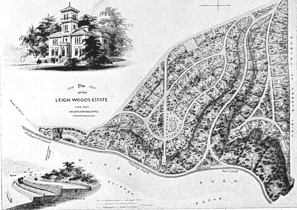
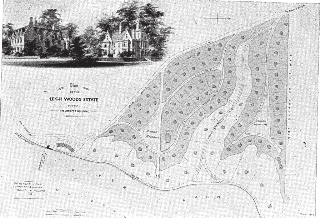
Large scale local and national opposition resulted in the Smyths drastically scaling back their plans for Leigh Woods, a 170-acre area which was to become “a little town” consisting of 435 houses, an iron bridge over Nightingale Valley, and a hotel.
The first developer that bought the land planned an even more extreme project, the construction of over 800 houses, prompting an outcry in the local press, but he failed to pay his first instalment of the purchase money to the Smyths and the land was returned to the family.
With the very real prospect of Leigh Woods being extensively developed still on the table, a group of wealthy Bristolians got together to form the Leigh Woods Land Company, which bought the area off the Smyths for £40,000. The firm then built a series of villas and parcelled up the land into sections worth £650 each. Contracts ensured that building was done sensitively and did not spoil the view from Clifton or the integrity of Nightingale Valley, which had been an oasis for locals and an inspiration for artists for centuries.
The Hatter builds “Overvale” (1874-1880)
The original plot was bought from the Leigh Woods Land Company by Alfred Thornley (1842-1907). It looks as though there was an initial agreement to buy the land in December 1865, on the condition of the Land Company and Thornley paying off the remainder of the funds due to Greville Smyth. This was finally completed in October 1874.
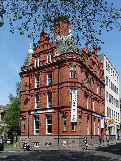
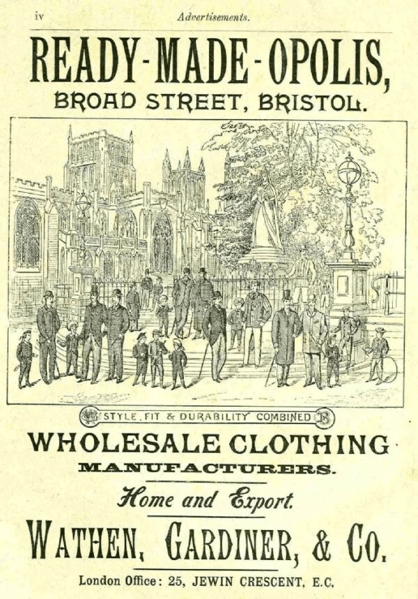
Thornley worked as a “clothier, outfitter and hatter” in Bristol, trading with his brother under the name of “Alfred and Edward Thornley”. The Thornleys were based at 17, Clare Street in the Old City, a patch that was subsequently demolished to build a new office for Prudential designed by Alfred Waterhouse – the architect behind the Natural History Museum and an array of other Prudential buildings built in the same style.
They then moved nearby to 31, High Street. This property also no longer stands. In a period when everyone wore hats, and department stores were yet to establish themselves, it was outfitters such as the Thornleys that were the go-to for people who could afford their wares. An 1871 trade directory for Bristol shows over 30 hatters were operating in the city, most based around Bristol’s medieval core (the area fanning out from the original crossroads of Wine Street, Broad Street, Corn Street and High Street). The two brothers were the offspring of Charles Frederick Thornley, himself a hatter based in the city.
Thornley married Elizabeth Wathen (1839-1905) at St Barnabas in 1864. Her father is listed as having been a retired victualler, and by the time of marriage simply a “gentlemen” but it is reasonable to assume a connection with the clothing industry given the Wathen name. Elizabeth’s brother, Sir Charles Wathen, was a clothing entrepreneur who was six-times Mayor of Bristol, a Chairman of the Grateful Society and a Justice of the Peace.
Thornley secured not only the land the house stands on now but shortly after he purchased two additional plots behind the house, today occupied by properties that were once servants’ dwellings and stables for the main house and the land where several other buildings now stand. Up until 1936, the land consisted of this entire L shaped plot, which bent around the next-door property.
The original construction, which is the core of the modern property, was probably completed in the late 1870s and was known as “Overvale”, literally meaning “over the valley”. It is not clear whether Thornley ever actually lived in Overvale. Clifton and its surrounds have always been the target of property speculation and it is likely that the land purchases and the build were done as an investment, rather than for the establishment of a family home
The Leigh Woods Land Company were highly prescriptive in the sort of house they wanted to see built on the Smyth’s former land, detailing the sort of stone, roof tiles and style of any house constructed there.
Overvale was built in a no-frills late Victorian classical style, the slightly ornamental string course between the two floors being the only particularly decorative item on the exterior. The striking extensions to the dining room and living room, with their shields and mock arrow slit, were made by later owners, probably the Ways in the Edwardian period, and are in the Tudor Revival style that had become popular towards the end of the 19th century.
Thornley ended his business partnership with his brother in February 1876, with a view to continuing the business himself.
